Personal Review
My take on this trail.
The Ride
The Martin Goodman Trail is 22 kilometres, running from the Beaches in the east to Humber Bay in the west. For almost the entire length, Lake Ontario is right there beside you. This is the trail that makes Toronto feel like a different city. Not the vertical, glass-and-concrete Toronto, but the horizontal one. The one that stretches out along the water and breathes.
I usually start from the Beaches. It's a quiet beginning – sand, shallow water, the skyline sitting low and distant. From there, the trail heads through the Port Lands, where the city is still being built. It feels like you're watching a waterfront decide what it wants to become.
As you pass people walking by, you begin noticing they're holding beavertails and gelato. The unique smell of churros, shawarma, and lake air mix together. Buskers set up on the pier with the CN Tower directly behind them and the marina boats in front. You can embrace it all at the Toronto Music Garden by the grass stairs, or take in the hidden skyline view from Ireland Park. The whole waterfront is layered with sound and movement, and riding through it feels less like exercise and more like being inside the city's best version of itself.
The trail never stays the same for long. Every kilometre is a different scene. Marina to sculpture garden to restaurant strip to quiet beach to urban lookout – and then it shifts again. You're never riding the same stretch twice, even when you are.
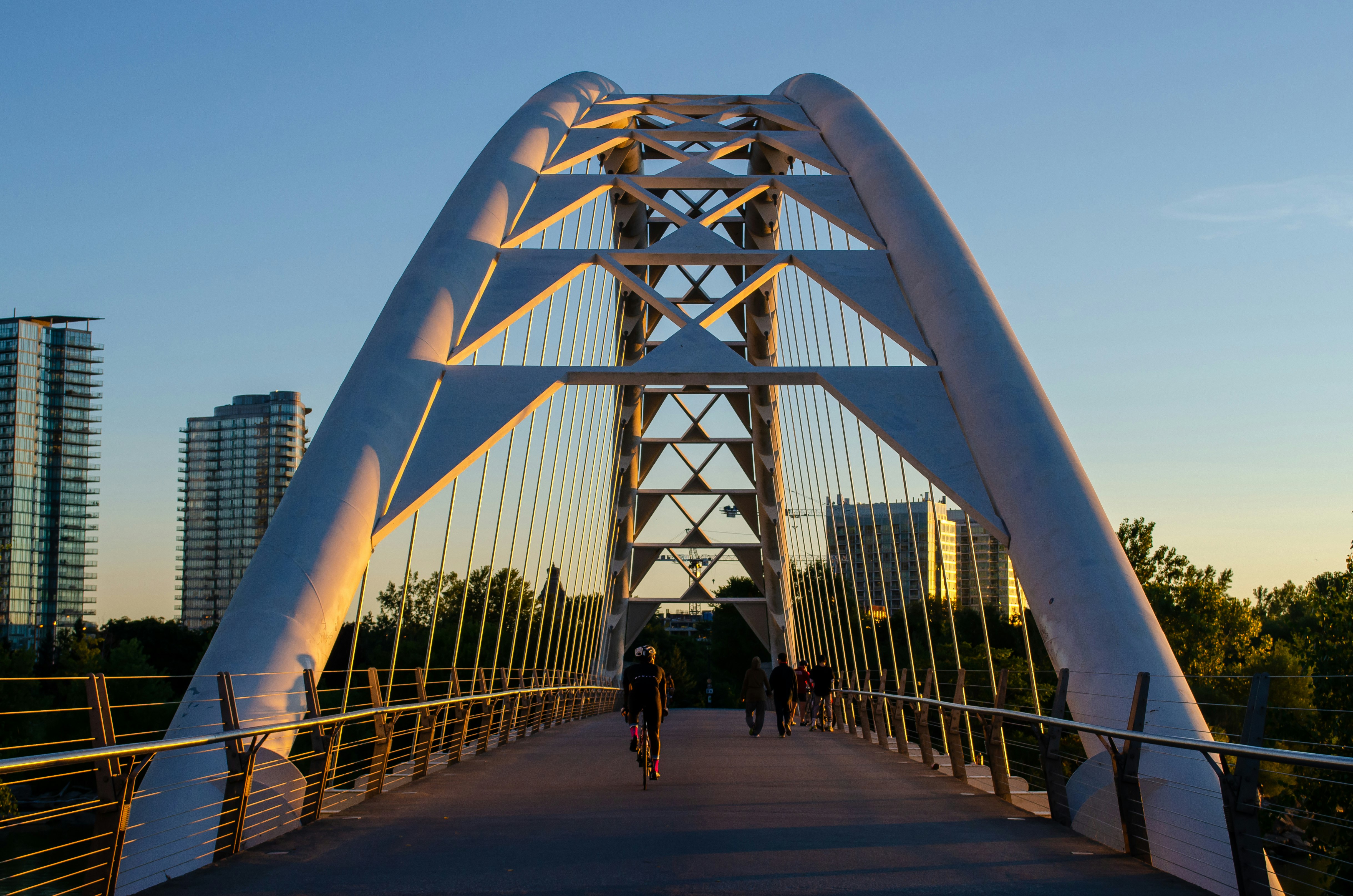
Past Ontario Place, the trail cuts through Trillium Park, which is worth a detour if possible. As you reach Marilyn Bell Park, the path widens out along a stone promenade right at the water's edge. The lake is flat and calm here, and there's nothing between you and the open water except a low railing. You can see the Humber Bay Arch Bridge in the distance, getting slowly closer. Passing through Sunnyside, the scene of the beach fills the ride with energy.
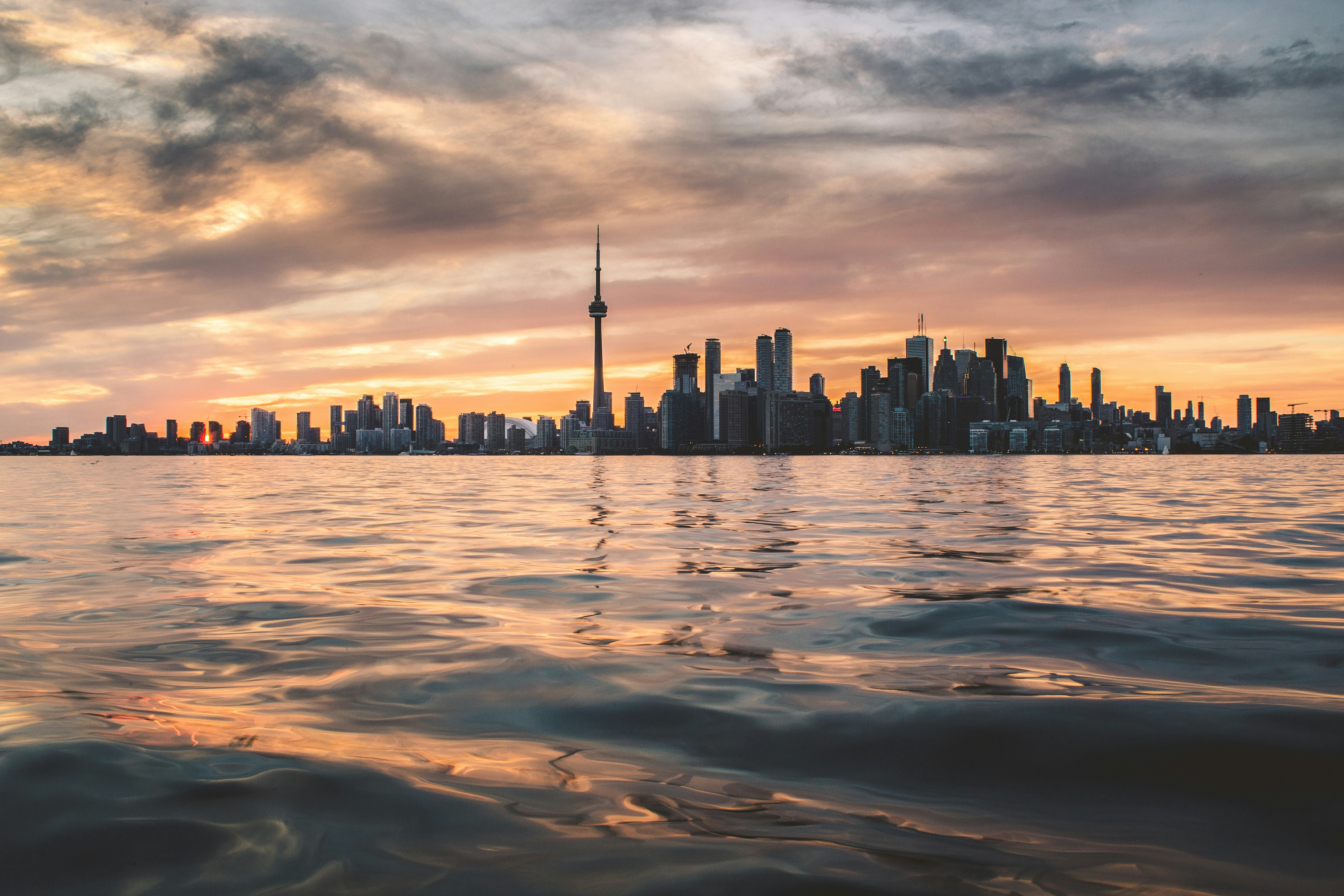
Then the trail curves out toward the Humber Bay Arch Bridge. Ride out to the middle and stop. The full Toronto skyline sits, framed by open water and sky, with the CN Tower centred like someone placed it there on purpose. You've seen it in photos. It's better from a bike.
Almost the whole thing is flat. You could ride it on a cruiser with no gears and feel fine. That's part of what makes it so good for every level of rider – the only challenge is distance, and you choose how much of that you want.
What You'll See
The view changes constantly. Within 22 kilometres, you pass through half a dozen completely different versions of the waterfront. The Beaches feel almost like a small town. The boardwalk, the lifeguard chairs, the smell of sunscreen and lake air. The Port Lands have that edge of something still being made. Harbourfront is the most alive section of any trail in Toronto – waterfront restaurants with patios pushing right up to the path, the CN Tower looming overhead, the harbour full of boats, and people everywhere doing exactly what a waterfront is for.
Further west, the Exhibition grounds carry you past old CNE buildings and the Ontario Place pods sitting out on the water like something from a different era. And then Humber Bay: wide-open sky, herons and swans in the wetlands, the arch bridge ahead of you, and the skyline behind you getting smaller with every pedal stroke. The trail gives you the whole city from a perspective most people never see.
When to Ride
Summer is the obvious season, but it's also the busiest. If you want the trail to yourself, go early. A weekday morning in June or September, before nine, is about as good as it gets. Warm air, calm water, long light, and almost nobody around. The Harbourfront section transforms completely when it's empty. You can hear the water slapping against the dock pilings, and the city feels like it hasn't woken up yet.
Autumn is underrated on this trail. The Humber Bay end gets beautiful in October, with the shoreline trees going gold against the grey lake. The wind picks up in fall, and riding west into a headwind off the water is a workout, but riding east with it at your back is one of the best feelings on a bike.
Winter is possible and surprisingly rewarding if you dress for it. The lake doesn't freeze here, but the air off the water is cold and sharp, and the trail is nearly empty. The light in winter is low and dramatic, and the skyline looks different. It's harder, more defined, and stripped of the summer haze. It's not comfortable, but it's worth it once or twice a season.
Worth Knowing
The trail is named for a person worth knowing about
Martin Goodman was the editor-in-chief of the Toronto Star who died in a cycling accident in 1981. He was hit by a car while riding his bike near his home. The city named its new waterfront trail after him the following year, a gesture that was partly tribute, partly statement. Building a dedicated cycling path along the lake and naming it after a cyclist killed by a car was the city saying something about what the waterfront should be: a place where people on bikes belong.
That history sits underneath every ride. You don't have to think about it. But it's there. Every protected stretch of pavement, every bollard separating you from traffic, every section where the trail runs uninterrupted along the water. That's the promise the name carries.
You're riding on a path that exists because someone believed cyclists deserved the waterfront.